Robots carry out pipeline inspection in Jiangbei district
Ge Jieru
Updated:2015-04-08
chinadaily.com.cn


Jiangbei district has constructed a new Geographic Information System (GIS) to make a comprehensive detection of the area's underground pipe networks, according to the Jiangbei landscape bureau. The new system incorporates robot, radar and sonar technologies to enable an efficient survey of the pipes.
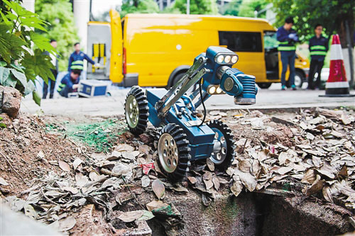
According to a senior staff member from Jiangbei landscape bureau, the system is produced by Wuhan Ordnance Factory and includes three parts: a pipeline robot platform, sonar radar truck and the data analysis management system. The pipeline robot platform is responsible for guiding the robot into the pipelines and generating video information.
The total length of the underground pipe networks in Jiangbei district is about 600 kilometers.
Before the GIS system was constructed, workers had to dig up the roads to check where the pipe networks went wrong. However, the pipe networks often contain toxic gasses such as hydrogen sulfide, making the robot a safer option.
 |
|
A pipeline robot prepares to enter the underground pipe networks in the Jiangbei district of the Liangjiang new area, Chongqing municipality. [Photo/Chongqing Daily] |
Edited by Jacob Hooson

Video

John Edwards, the UK trade commissioner for China, praised Chongqing over its rise as a burgeoning center in intelligent manufacturing.